By RANDY MANN
La Nina, the cooler than normal sea-surface temperature event in the South-Central Pacific Ocean, has been weakening over the past 3 to 4 weeks, but it's still strong enough to influence global weather patterns. Readings along the Equator are still averaging about 1 to 3 degrees below normal.
It's likely that this cooler than normal sea-surface temperature phenomenon has already peaked and won't come near the La Nina event of 2010, which was one of the strongest ever recorded and led to very snowy conditions across the North Country.
But, we've been seeing a "back and forth" pattern of cooling and warming over the last several months. There were indications that La Nina was going to completely fall apart last November, before regaining some strength in December.
According to the Climate Prediction Center, the majority of the computer models are predicting that La Nina has peaked, but its effects will continue through the rest of the winter season and perhaps into the early spring of 2012.
It's still possible that we could see a very cold and snowy late January and February in the northern regions. We've already seen increased snowfalls across the northern U.S. and southern Canada in the past 10 days. Despite the recent heavy snows, the snowfall totals of the 2011-2012 season won't compare to the big snow years of 2007 and 2008. There have been La Nina years, combined with increased solar activity, that saw near to 'below' normal snowfall totals across the northern U.S. As usual, only time will tell.
SOLAR STORMS ARE INCREASING AGAIN
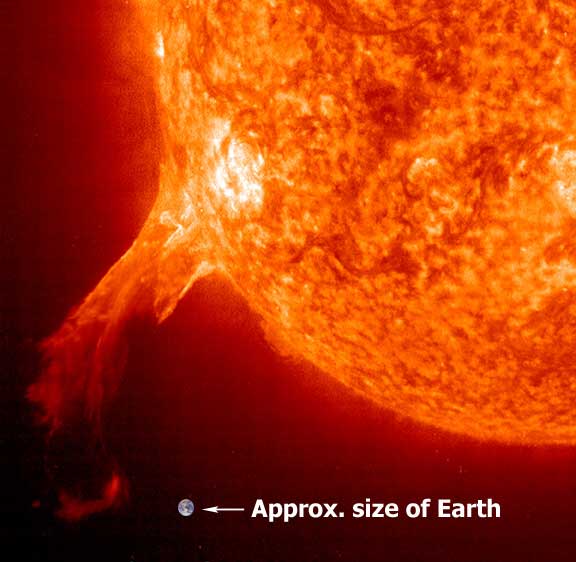
Solar activity continues to be relatively high as we move through the winter season. Within the last 10 days, sunspot numbers ranged from a low of 88 on Jan. 20 to a high of 152, on Jan. 17, the highest number for the month. Compared to the average number of sunspots from November and December, the recent figures have picked up.
Another sign our sun is becoming more active is a massive solar storm that 'bombarded Earth' early Tuesday, Jan. 24. The huge solar flare erupted from the sun late Sunday and was traveling at 3 million miles per hour. We are approximately 91 million miles at this time of the year away from the sun. The radiation from this event hit the Earth at various times in a matter of days.
This massive storm was the strongest since May 2005, but was considered to be only a moderate "solar mass ejection event." The worst of the storm was expected to go to the north of our planet. But, Polar-traveling airplanes had to be diverted for safety issues. The high dose of radiation from the sun can often lead to satellite disruptions and other communication problems.
During the 'peak' of the last solar maxima in the late 1990s, we were seeing 200-300 solar storms each day. It's quite possible that we may see similar numbers by late this year. Right now, we're averaging near 100 sunspots a day and this solar "maxima" cycle is not expected to peak until late 2012 or early to mid 2013. The increased solar activity may be one reason why the northern areas of the U.S., as well as southern Canada, have not seen the heavy snowfalls like those during the La Nina years in 2007, 2008 and 2011, despite some increased snows over the last 10 days.
Many scientists warn that the upcoming maxima will be very strong and may create many problems for power companies, satellites and other electronic devices like cell phones. We're already seeing an increase in massive solar flares ejected from the sun that has the potential of causing satellite and other communication problems. Back in 1989, a solar storm was strong enough to literally shut down a power plant in Canada.
Cliff and I believe that the upcoming maxima will be relatively strong. If La Nina continues to at least maintain its strength and solar activity increases over the next 12 to 18 months, don't be surprised to hear about more fluctuations of the Earth's temperature, probably to the upside. But, on the back side of the solar maxima, global temperatures could decrease, at least slightly, but once again, only time will tell.
NORTH IDAHO WEATHER REVIEW AND LONG RANGE OUTLOOKS
By CLIFF HARRIS
Nearly 26 inches of snow had fallen this month of January, a whopping 25 inches during the second half of the month, as of 10 a.m. on Thursday, Jan. 26.
Our normal January snowfall since 1895 has been 21.4 inches in Coeur d'Alene. Last January, in 2011, we gauged 16.8 inches of the white stuff, a bit below normal, before going on to a nearly double normal seasonal snowfall total by June 30 of 121 inches. Our seasonal normal has been 69.8 inches over the past 117 years.
Ironically, despite having the least snow on record between Nov. 22, 2011 and noon on Jan. 16, just 6.3 inches, we reached a near-normal 42.3 inches of snow for the 2011-12 winter season in town by Jan. 26. The normal seasonal snowfall by Jan. 26 since 1895 was 45.9 inches, just 3.6 inches above our 2011-12 total of as of Thursday.
Nearly 2.60 inches of liquid precipitation had been measured this month as of 10 a.m. on Jan. 26, about an inch less than normal since Jan. 1. But, remember, only a scant .38 inches of moisture was gauged during the first half of January, the driest such period on record in Coeur d'Alene.
Where do we go weatherwise from here? In my climatological opinion, it depends upon just how fast the current 'La Nina' falls apart in the tepid waters of the Pacific Ocean.
I believe the snowiest part of the winter of 2011-12 has ended. I see only 20 inches more of the white stuff falling in February, March and April, less than normal. This would push our seasonal total by June 30 to around 63 inches, very close to my seasonal forecast of 63.4 inches updated in late December.
But, once again, only time will tell.
Cliff Harris is a climatologist who writes a weekly column for The Press. His opinions are his own. Email sfharris@roadrunner.com